Within Rendlesham
Why the Base Location Matters
The layout of RAF Woodbridge, Bentwaters and Rendlesham Forest shaped what witnesses could see and how the story unfolded.
On this page
- RAF Woodbridge and Bentwaters
- Forest paths and perimeter fences
- Sight lines toward distant lights
Page outline Jump by section
Introduction
RAF Woodbridge matters to the Rendlesham Forest UFO incident because the geography did much of the work. The reported lights were not seen from an isolated country lane, but from the edge of a Cold War air base whose eastern perimeter pressed into Forestry Commission woodland, with RAF Bentwaters close by and the Suffolk coast beyond. That setting shaped the first interpretation: security personnel saw lights beyond the base fence, feared a possible aircraft incident or intrusion, and moved from a controlled military space into dark, uneven forest. The same setting also shaped later sceptical explanations, because the line of travel from Woodbridge’s East Gate led roughly eastwards through the forest towards open fields, the coast, and the former Orford Ness lighthouse. The key point is not that geography “solves” Rendlesham by itself, but that it explains why ordinary lights, military concern, restricted access, and forest navigation became entangled so quickly. The National Archives describes the case as lights near the rear gate of RAF Woodbridge, investigated in Rendlesham Forest on two nights by USAF personnel. [The National Archives]nationalarchives.gov.ukThe National Archives UFO reportsThe National ArchivesUFO reports - The National Archives…
Why RAF Woodbridge was an unusual base to begin with
RAF Woodbridge was not laid out like a typical small rural airfield. It began as a Second World War emergency landing ground, built to receive damaged bombers coming back across the North Sea. The Imperial War Museums describe Woodbridge as the first of three Bomber Command emergency runways for damaged Allied aircraft returning from operations over Europe, opened on 15 November 1943 and administered as a satellite of RAF Bentwaters. [Imperial War Museums]iwm.org.ukOpen source on iwm.org.uk.
That origin left a striking physical footprint. Suffolk Heritage describes the wartime airfield as a “large slab of concrete carved through a pine forest”, with a huge runway 3,000 yards long and 250 metres wide, plus grass overshoot areas at either end. [heritage.suffolk.gov.uk]heritage.suffolk.gov.ukSU T 197SUT 197 - RAF Woodbridge; Woodbridge Airfield; RAF Sutton Heath - Suffolk Heritage Explorer… The RAF Museum explains the broader emergency-runway design: these east-coast runways were much wider than normal, divided into lanes by lights, and aligned east to west so damaged aircraft could line up more easily. [RAF Museum]rafmuseum.org.ukRAF Museum Emergency landing service | Worth a Thousand WordsRAF MuseumEmergency landing service | Worth a Thousand Words - Air Diagrams | Archive Exhibitions | Exhibitions & Displays | Research | R…
For the Rendlesham incident, that physical layout matters in three ways. First, Woodbridge was already a base built into and around forested terrain, not a neat airfield separated from the countryside by a wide urban buffer. Second, its east-west orientation meant the eastern end of the base pointed towards Rendlesham Forest and, beyond it, the Suffolk coast. Third, because the site had a long military history, lights or movement beyond the fence were not just rural curiosities to those on duty; they could plausibly be read as a possible aircraft emergency, perimeter incident, or security problem.

RAF Woodbridge and Bentwaters
By 1980, RAF Woodbridge and RAF Bentwaters functioned as closely linked American-operated “Twin Bases”. Bentwaters Cold War Museum records that Woodbridge was made available to the United States Air Force in 1952, that the 79th Fighter-Bomber Squadron arrived at Woodbridge that October, and that from July 1958 Woodbridge operated as a twin airfield with RAF Bentwaters under the 81st Tactical Fighter Wing. [bcwm.org.uk]bcwm.org.ukThe Bentwaters Cold War Museum…
Bentwaters itself sat just to the north-east of Woodbridge and had its own wartime and Cold War geography. The Bentwaters site was selected because it was flat, remote, sparsely populated and only a few miles from the coast. [bcwm.org.uk]bcwm.org.ukThe Bentwaters Cold War Museum… Those qualities were useful for military aviation, but they also created the landscape in which Rendlesham unfolded: large secured airfields, patches of heath and conifer plantation, limited nearby settlement, and a dark coastal horizon where beacons, stars and aircraft lights could stand out sharply.
The two-base arrangement also helps explain why accounts of the incident often shift between “Woodbridge”, “Bentwaters” and “Rendlesham Forest”. The first reported activity was associated with the Woodbridge perimeter, especially the East Gate or rear-gate area. Bentwaters mattered because it was part of the same USAF operational world, with command, personnel and later public memory often treating the bases as a combined Cold War complex rather than two wholly separate places.
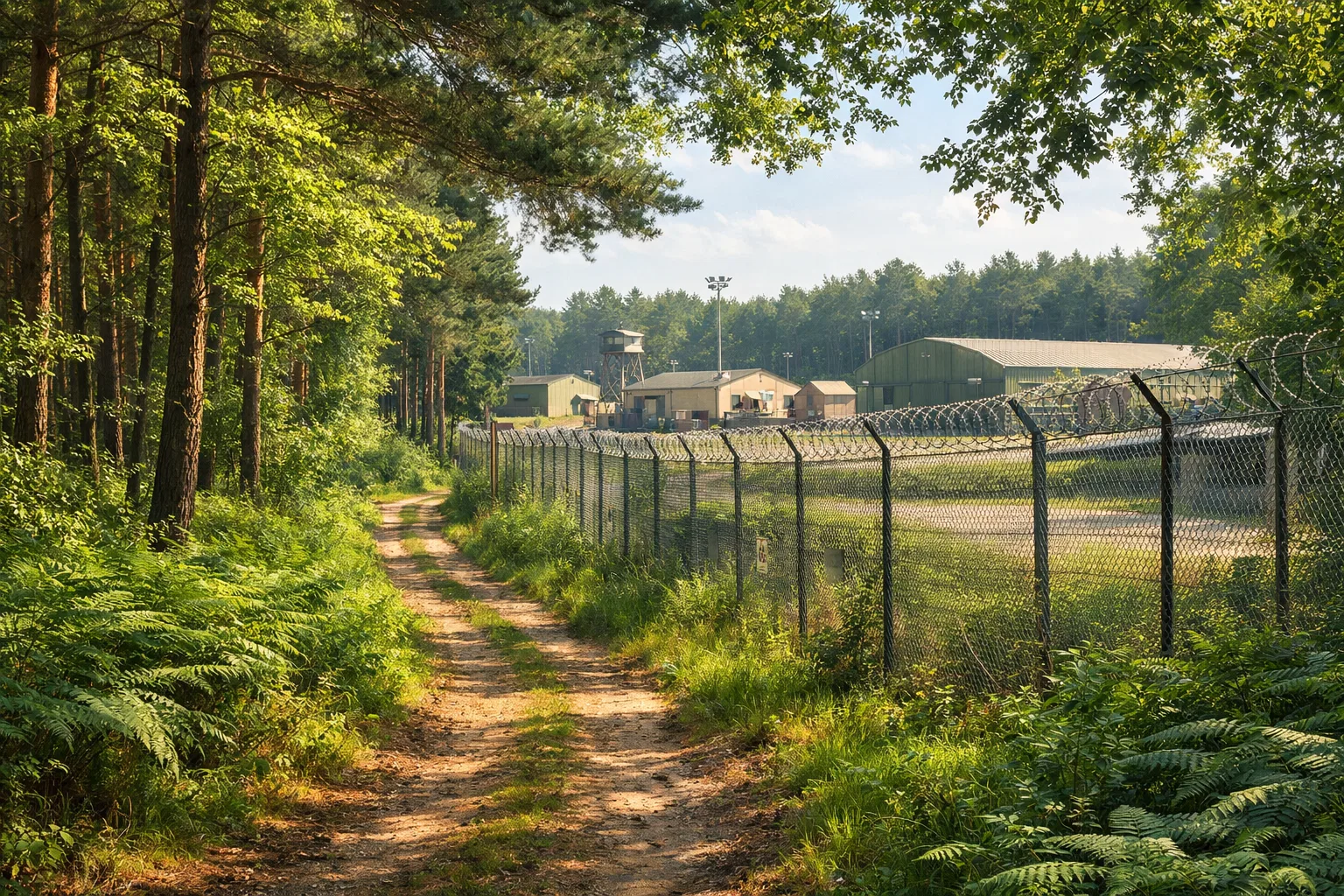
This matters for interpretation. A witness at Woodbridge was not simply “in a forest”; he was at the edge of a defended air base. A light in the trees was therefore not just a light in the trees. It was outside the fence, close enough to prompt a security response, but far enough into civilian or forestry land to make identification difficult.
Forest paths and perimeter fences
The most important boundary in the geography of the incident was the transition from base to forest. The National Archives places the reported lights near the rear gate and says servicemen investigated Rendlesham Forest on two separate nights. [The National Archives]nationalarchives.gov.ukThe National Archives UFO reportsThe National ArchivesUFO reports - The National Archives… That detail is central: the case began at a perimeter, where base security, woodland tracks and civilian land met.
Rendlesham Forest itself was not a single open clearing. Forestry England’s current UFO trail description still emphasises a mixed route through forest, heathland and wetlands connected with the December 1980 sightings. [Home | Forestry England]forestryengland.ukHome | Forestry England UFO trail at Rendlesham Forest | Forestry EnglandHome | Forestry England UFO trail at Rendlesham Forest | Forestry England The modern trail is a visitor route, not a perfect reconstruction of every 1980 movement, but it preserves the basic geographical fact that the story belongs to a working forest landscape of tracks, plantations, rides and uneven ground.
That terrain helps explain why accounts can sound both close and distant at the same time. From a gate or track, a light may appear to be just beyond the trees. Once someone starts walking, the same light can seem to recede, shift behind trunks, or appear and disappear as the viewer’s line of sight changes. In a plantation forest, small changes in position matter: a gap between trees can briefly frame a far-off beacon, while a few steps to either side can hide it again.
The perimeter fence also gave the incident a psychological structure. Inside the fence was an American military base with patrols, procedures and chain of command. Outside it was dark forest. Crossing that boundary changed the witnesses’ task from routine security observation to field investigation. That is one reason the setting became so memorable: the story was not just “men saw lights”, but “base security personnel left the perimeter and entered the forest to investigate lights”.

Sight lines toward distant lights
The most contested geographical question is whether some of the reported lights could have been distant lights seen through or beyond the forest, especially the former Orford Ness lighthouse. Forestry England’s Rendlesham UFO leaflet identifies the Orford Ness lighthouse as approximately six miles away in connection with the unusual lights reported in December 1980. [Home | Forestry England]forestryengland.ukRendlesham UFO Leaflet (Jan 23Home | Forestry EnglandRendlesham Forest UFO Trail27 Sept 2023 — The Orford Ness lighthouse, approx. 6 miles. Unusual lights were seen… Sceptical investigator Ian Ridpath’s route analysis argues that the movement into the forest led in the direction of the lighthouse to the east, and his photo notes add an important nuance: the lighthouse was not directly visible from East Gate, but became apparent farther into the forest where the land and sight lines changed. [Ian Ridpath]ianridpath.comIan RidpathRendlesham Forest UFO - The route into the forestIt should be clear from this map that they were heading in the direction of…
That nuance is important because it avoids an over-simple version of the sceptical argument. The claim is not necessarily that a guard standing at the gate had a clear, uninterrupted view of a lighthouse and simply failed to recognise it. The more geography-sensitive claim is that witnesses moved through a complex landscape where distant lights could intermittently appear through gaps, over lower ground, or beyond the forest edge.
The line-of-sight issue also explains why Rendlesham remains debated. Supporters of the extraordinary interpretation argue that the witnesses described coloured, moving, close-range lights and, in some accounts, an object in the trees. Sceptics reply that at least some reported lights fit known distant sources, especially when seen at night by people moving through woodland. The geography does not settle every witness statement, but it does show why “near” and “far” became unstable categories during the incident.
The Guardian’s 2026 retrospective illustrates the same tension in narrative form: it recounts airmen moving from the Woodbridge East Gate area towards the woods, later reaching open ground where a flashing light in the distance was identified in the account as Orfordness lighthouse. [The Guardian]theguardian.comOpen source on theguardian.com. Even where one treats later witness memories cautiously, that basic spatial pattern — gate, forest, field, coastward light — is the recurring geography of the case.
Why the base location changed the story
RAF Woodbridge’s location made Rendlesham more than a rural lights-in-the-sky report. The eastern edge of the base was close enough to Rendlesham Forest for a light beyond the fence to feel operationally relevant. Bentwaters nearby made the area a wider American military complex rather than a single isolated station. The coast added navigational lights and distant horizons. The forest added concealment, broken sight lines and difficult night movement.
Several mechanisms flowed from that geography:
Security meaning: A light outside a military perimeter carries a different meaning from the same light seen from a village road. It can imply a crash, intrusion, aircraft problem or threat to base security.
Distance confusion: Woodland makes it hard to judge range at night. A light beyond the trees can look close, especially if the viewer has no clear intermediate landmarks.
Intermittent visibility: A beacon or aircraft light can appear to move or vanish when seen through trunks, branches, slight rises and dips in the land.
Base memory: Because the witnesses were USAF personnel at a Cold War installation, later public interest attached special weight to their observations, even though the Ministry of Defence’s archival position was that the incident showed no defence significance.
The geography therefore acts as a bridge between the competing readings of Rendlesham. For believers, the base setting gives the incident seriousness: trained personnel, guarded perimeters and a sensitive Cold War location. For sceptics, the same setting provides the ingredients for misperception: night duty, expectation of danger, forest movement, and distant coastal lights.

What the setting can and cannot explain
The RAF Woodbridge setting can explain why the incident escalated quickly. It can explain why the first response was practical and security-led. It can explain why a witness might move from seeing lights near the forest to believing something had come down beyond the perimeter. It can also explain why later investigators focus so closely on maps, tracks, gates, fields and the lighthouse line.
What it cannot do, by itself, is prove exactly what every witness saw. Geography is strongest where the claims involve direction, visibility, distance and movement. It is weaker where later accounts involve close-up object descriptions, alleged physical effects, or contested memories added after the original reports. Those parts of the wider Rendlesham story require separate treatment of witness testimony, documents and later retellings.
Still, the setting is not a background detail. RAF Woodbridge’s eastern perimeter, the linked Bentwaters-Woodbridge base system, Rendlesham Forest’s paths and plantations, and the coastward sight lines are the stage machinery of the case. Without that geography, the Rendlesham Forest UFO incident becomes a loose collection of strange claims. With it, the reader can see why the story unfolded in the particular way it did: a Cold War base looking out through dark trees towards distant lights.
Amazon book picks
Further Reading
Books and field guides related to Why the Base Location Matters. Use these as the next step if you want deeper reading beyond the article.
Encounter in Rendlesham Forest
Explains the geography, bases and setting central to Rendlesham.
You Can't Tell the People
Provides extensive background on the location and surrounding events.
The UFO Experience
Helps readers place Rendlesham within the wider history of UFO reports.
eBay marketplace picks
Marketplace Samples
Example marketplace items related to this page. Use the search link to explore similar finds on eBay.


Endnotes
-
Source: nationalarchives.gov.uk
Title: The National Archives UFO reports
Link: https://www.nationalarchives.gov.uk/explore-the-collection/explore-by-time-period/postwar/ufo-reports/Source snippet
The National ArchivesUFO reports - The National Archives...
-
Source: heritage.suffolk.gov.uk
Title: SU T 197
Link: https://heritage.suffolk.gov.uk/Monument/MSF21725Source snippet
SUT 197 - RAF Woodbridge; Woodbridge Airfield; RAF Sutton Heath - Suffolk Heritage Explorer...
-
Source: bcwm.org.uk
Link: https://bcwm.org.uk/museum/woodbridge/Source snippet
The Bentwaters Cold War Museum...
-
Source: bcwm.org.uk
Link: https://bcwm.org.uk/museum/bentwaters/Source snippet
The Bentwaters Cold War Museum...
-
Source: cdn.nationalarchives.gov.uk
Title: nationalarchives.gov.uk UF O files
Link: https://cdn.nationalarchives.gov.uk/documents/ufo-transcript-aug-09.pdf -
Source: iwm.org.uk
Link: https://www.iwm.org.uk/collections/item/object/205022754 -
Source: rafmuseum.org.uk
Title: RAF Museum Emergency landing service | Worth a Thousand Words
Link: https://www.rafmuseum.org.uk/research/archive-exhibitions/worth-a-thousand-words-air-diagrams/emergency-landing-service/Source snippet
RAF MuseumEmergency landing service | Worth a Thousand Words - Air Diagrams | Archive Exhibitions | Exhibitions & Displays | Research | R...
-
Source: forestryengland.uk
Title: Home | Forestry England UFO trail at Rendlesham Forest | Forestry England
Link: https://www.forestryengland.uk/rendlesham-forest/ufo-trail-rendlesham-forest -
Source: forestryengland.uk
Title: Rendlesham UFO Leaflet (Jan 23)
Link: https://www.forestryengland.uk/sites/default/files/documents/Rendlesham%20UFO%20Leaflet%20%28Jan%2023%29.pdfSource snippet
Home | Forestry EnglandRendlesham Forest UFO Trail27 Sept 2023 — The Orford Ness lighthouse, approx. 6 miles. Unusual lights were seen...
-
Source: ianridpath.com
Link: https://www.ianridpath.com/ufo/rendlesham2d.htmlSource snippet
Ian RidpathRendlesham Forest UFO - The route into the forestIt should be clear from this map that they were heading in the direction of...
-
Source: ianridpath.com
Link: https://www.ianridpath.com/ufo/[photos -
Source: theguardian.com
Link: https://www.theguardian.com/world/2026/apr/30/the-rendlesham-forest-mystery-its-the-perfect-storm-of-a-ufo-case -
Source: Wikipedia
Title: RAF Woodbridge
Link: https://en.wikipedia.org/wiki/RAF_Woodbridge -
Source: Wikipedia
Title: RAF Bentwaters
Link: https://en.wikipedia.org/wiki/RAF_Bentwaters -
Source: ianridpath.com
Link: https://www.ianridpath.com/ufo/rendlesham1b.html -
Source: ianridpath.com
Link: https://www.ianridpath.com/ufo/halttape.html -
Source: ianridpath.com
Link: https://www.ianridpath.com/ufo/rendlesham7.html -
Source: forestryengland.uk
Title: WEB VERSION OF UFO TRAIL
Link: https://www.forestryengland.uk/sites/default/files/documents/WEB%20VERSION%20OF%20UFO%20TRAIL.pdf -
Source: iwm.org.uk
Link: https://www.iwm.org.uk/collections/item/object/1060021135 -
Source: iwm.org.uk
Link: https://www.iwm.org.uk/collections/item/object/205090441 -
Source: iwm.org.uk
Link: https://www.iwm.org.uk/embed/?id=1060021135&media_id=630815 -
Source: suttonheath.onesuffolk.net
Link: https://suttonheath.onesuffolk.net/news-posts/view/1 -
Source: bentwaters-as.org.uk
Title: raf woodbridge
Link: https://bentwaters-as.org.uk/history/raf-woodbridge/ -
Source: suffolkmuseums.org
Title: Bentwaters Cold War Museum
Link: https://suffolkmuseums.org/museums/bentwaters-cold-war-museum/
Additional References
-
Source: youtube.com
Title: RAF Woodbridge: The USAF Base Time Forgot
Link: https://www.youtube.com/watch?v=FQA6urKrptkSource snippet
Inside Rendlesham Forest: Where Britain's UFO Landed...
-
Source: facebook.com
Link: https://www.facebook.com/HISTORY/posts/a-surreal-event-outside-a-us-air-force-base-near-the-rendlesham-forest-in-englan/1202258311467143/ -
Source: commons.wikimedia.org
Link: https://commons.wikimedia.org/wiki/File%3ARoyal_Air_Force_Bomber_Command_Emergency_Landing_Ground%2C_Woodbridge%2C_Suffolk_C5483.jpg -
Source: facebook.com
Link: https://www.facebook.com/sandlingsforest/posts/its-45-years-since-the-rendlesham-forest-incident-come-explore-our-ufo-trail-ins/1328904915708024/ -
Source: facebook.com
Link: https://www.facebook.com/groups/177620292284538/posts/25784887591131123/ -
Source: controltowers.co.uk
Link: https://controltowers.co.uk/airfields/woodbridge/ -
Source: alamy.com
Link: https://www.alamy.com/stock-photo/raf-woodbridge.html -
Source: facebook.com
Link: https://www.facebook.com/cwealthforces/posts/rendlesham-forest-ufo-incidentthe-rendlesham-forest-incident-was-a-series-of-rep/979233021295195/ -
Source: komoot.com
Link: https://www.komoot.com/highlight/1436942 -
Source: history.co.uk
Link: https://www.history.co.uk/articles/what-happened-at-the-rendelsham-forest-incident-britain-s-answer-to-roswell
Topic Tree